Development of Mt. Madonna Park is a story with lots of twists and turns
Several purchases and annexations make up the popular nature park
By Mike Monroe
Mike Monroe
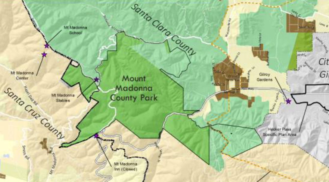
The parklands of Mt. Madonna did not come about through one large purchase of land from the heirs of the Miller Estate. The story of Mt. Madonna begins in 1850 when the state of California was established with 27 original counties including Santa Clara and Santa Cruz. The boundary between the two counties roughly follows the crestline of the Santa Cruz Mountains. However, looking at a current park map you will notice a substantial portion of today’s park sits on lands originally included in Santa Cruz County.
In addition, nearly 1,000 acres of parkland are located across Hecker Pass Highway along Whitehurst Road. There are no connections to these properties from the Sprig parking area and they are not open for public recreation. There are 910 acres along Redwood Retreat Road that have been acquired during the years and await development plans. Today, Mt. Madonna County Park totals 4,605 acres with about 400 of those acres developed as campgrounds, picnic areas or other park infrastructure.
In the mid-1850s George Bodfish bought a part of the French Redwoods with the intention of logging and milling them for sale in both Santa Cruz and Santa Clara counties. In a newspaper story from May 26, 1928, recalling the dedication of Hecker Pass Highway, Edward White wrote in the Evening Pajaronian about George Bodfish.
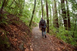
Photo Hiking Project
A lone hiker walks through the redwoods forest at Mt. Madonna County Park.
“Bodish was an energetic man from Maine who was also engaged in a San Jose-based lumber business. A Santa Cruz County land survey (probably 1858) suggested that Bodfish had encroached on lands that were on the western slope of the mountains in Rancho Salsipuedes. A legal dispute ensued, but a compromise was reached between the parties . . . The breakthrough came when a lunch was proposed by Bodfish who brought a large hamper with him containing generous portions of chicken, turkey, some champagne and other luxuries. The agreement was most favorable to Bodfish as he maintained his original access to the well-timbered redwood forest lands, within the boundary of Santa Cruz’s Rancho Salsipuedes, for the cost of an embellished picnic. Subsequently those lands were legally transferred into his ownership.”
The machinery for the Bodfish lumber mill was brought from Boston on a sailing ship.
Portions of Rancho Salsipuedes had also been acquired by Henry Miller during the 1870s. Future land annexations from Santa Cruz County into Santa Clara have totaled 5,400, most of which came from Rancho Salsipuedes (the original grant was for 31,201 acres). The Miller and Lux firm eventually owned much of Rancho Salsipuedes and the Rancho Bolsa de Pajaro which was adjacent to the Pajaro River extending to its outlet in Monterey Bay. It is difficult to conceptualize the hundreds of thousands of acres that were once owned or controlled by Miller and Lux.
 When Santa Clara County and the Miller Estate negotiated the first purchase of Mt. Madonna property in October 1927, the acreage was mostly located in the lower elevation areas of today’s park. Miller had always intended that his summer retreat near the summit would revert to a park, but neither the state of California nor the Santa Clara County was equipped to manage such a purchase. In addition, at the time of his death in 1916, the beginnings of World War I were rumbling plus the very complicated structure of his estate postponed any idea of public acquisition.
 According to the Oct. 29, 1927, edition of the Gilroy Advocate the initial park purchase proposal included slightly less than 2,400 acres surrounding today’s Sprig Day Use area, with 554 of those acres located across Hecker Pass along Whitehurst Road absorbing the old Lewis and McDowell ranches.
An original ranch house plus barns and sheds located at 7949 Whitehurst Road became the first outpost for Henry Miller’s Mt. Madonna development plans. Additionally, 540 acres of Rancho Salsipuedes land along the ridge were to be a part of this first purchase (but this was not finalized until 1930). The total acreage in this first transaction was 2,934 acres and the total cost was $60,000. The entire Mt Madonna area was largely recovering from intense logging operations and subsequent slash burning — it was a patchwork landscape.
 The Miller heirs continued disposing of Mt. Madonna properties through 1961. The summit area including the home sites of Henry Miller’s summer vacation bungalows totaling about 200 acres were transferred in 1953 to the newly established Santa Clara County Parks Department. In 1971, an awkwardly shaped parcel (about 420 acres) called the Bay View was annexed from Santa Cruz County. A small easement of about 20 acres was obtained by SCC Parks in 1980. It may serve as a future access point along Redwood Retreat Road.
In 1991, two parcels along Summit Road, diagonally across from the intersection of Pole Line Road and Mt. Madonna Road, were integrated into Mt. Madonna Park. Both were in Santa Cruz County so a number of legal hurdles had to be surmounted. Photos taken in the 1970s of the Arata and Garcia properties (264 acres) show them to be used for cattle grazing with a large barn in the middle of a pasture. Today the lands are overgrown, but may be developed depending upon the implementation of the 2017 Mt. Madonna Master Plan. Mt. Madonna Road was originally called the Watsonville Road or the Gilroy Toll Road. It is likely a gate close to the intersection, with a nearby residence, served as the toll collection site during the 1860s.
The year 1997 saw two major additions — the 436-acre Greeninger Falls Ranch near Summit Road and the 400-acre Nielson property which extended for one-half mile along Redwood Retreat Road. The Nielson purchase was contentiously debated by residents as there were concerns about increasing traffic along Redwood Retreat and possible vandalism from potential users. A proposal for an equestrian staging area, at the Nielson Barn on Mt. Madonna Road as it angles away from Redwood Retreat, was adamantly opposed. The Nielson home, which was easily seen from the Old Mine Trail, was removed soon after acquisition, although the adjacent pond remains. The mine, known as the Arthur Mine, produced chromium prior to 1876. At the moment, there is no other information about this integral property purchase which probably involved more than just one parcel.
In 2009, the Clark Ranch (408 acres) on Whitehurst Road was purchased and in 2014 the Della Maggiora-owned Triple Buck Ranch (490 acres) were added. Burt and Veda Clark owned Clark’s Jewelry in Gilroy and in 1948 they bought the ranch that featured an established walnut orchard. Frank Della Maggiora was a real estate developer and the last surviving partner of a group (1973) of local hunting enthusiasts who enjoyed a cabin off Redwood Retreat Road. Both the Clark and Della Maggiora homes and outbuildings were built using old growth redwood lumber. All the buildings were removed by SCC Parks after purchase.
A final note — since only 10 percent of Mt. Madonna County Park is considered to be developed, and the 2017 Master Plan primarily addresses potential projects in the summit area, the remaining 4,200 acres are classified as “resource bank lands.”

Gilroy.He is amateur historian and naturalist focusing on South
County in coordination with Santa Clara County Parks, California
Passport Tours, Friends of the Winemaker, the Wineries of Santa
Clara Valley and the Historical Societies of Gilroy and Morgan Hill.
- Hike with Mike: Olive growers commit to regenerative organic farming for their oils - April 17, 2024
- Take a Hike … with Mike Monroe: 53rd anniversary of Earth Day to be celebrated at Christmas Hill Park - April 3, 2023
- Take a Hike … with Mike Monroe: Chitactac-Adams park lives on; volunteer opportunities abound - January 24, 2023